

Ireland in general is according to the Koppen/Geiger classification scheme is classified as a Cfb climate. According to this classification we see that Ireland which is located at 53N 20’ N and 6 16’ W is considered a warm temperate, fully humid, warm summered climate, and if you compare this to locations that fall at the same latitude in Canada (which we know in general tends to have colder winters) you start to wonder why is this?

In this map of Ireland we can see that it is fully surrounded by water on all side, and if you notice Dublin is located on the Eastern coast closest to the Irish Sea and English Channel.
First off Ireland is surrounded by two large bodies of water—the Atlantic Ocean and the Irish Sea, but you might wonder how it so warm in Ireland when appears to be a fair distance from the equator lying at 53 N? This is because of the warming influence of the North Atlantic current.
Ireland is not only surrounded by water but is in close proximity to the movement of warm water which allows for it be warmer than places in Canada which tend to be nearer colder bodies of water and have larger land masses.

This images shows us the amount of sunlight Ireland recieves at different times of year which can vary between 8 hours at most in summer and 3 hours in the winter; however, most of the time Ireland has a fairly thick layer of clouds that block out most of the sun's rays.
So we now have an idea of why Ireland experiences such temperate conditions, but is it that Irelands temperatures never reach into the 70’s or 80’s even though the humidity on the ‘island’ tends to be into the 90’s? Well according to the information I have found this has a lot to do with the fact that Ireland is located farther away from the heating of the equator, but it has more importantly to do with the amount of sunlight or solar radiation that penetrates Ireland.

This is another image that shows the average sunshine in Ireland.
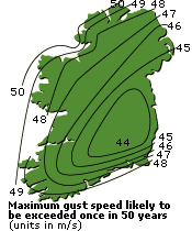
Other factors effecting Ireland are wind, rain, and cloud cover. Rain and cloud cover the last few years have remained about the same over the last few years, but when it comes to wind Ireland has seen some high winds and on November 30, 2011 was under a tropical warming watch for Invest 90 and also a high wind advisory.

Both of these images show the movement and intensity of Invest 90 in relation to Ireland.

In 2011, Hurricane Katia touched down in Northern Ireland bringing wind speed up of 80mph across Ireland. This hurricane swept across the northern part of the country destroying houses and buildings. The effect this hurricane had on Ireland was due to the fact that Ireland topography is generally flat especially compared to the mountainous region of Colorado.

In this image we see the movement of Hurricane Katia, and it's relation to Ireland.

The prevailing winds in Ireland come up from the south and west bringing warm air. For those in Dublin, these winds are minimal compared to other parts of Ireland because of the Mountians in located south of Dublin.

In these two images you can see the movement of the wind across Ireland.
Work Cited:
http://www.wunderground.com/tropical/tracking/at201190_model_intensity.html
http://www.wunderground.com/tropical/tracking/at201190_ensmodel.html
http://www.met.ie/climate-ireland/sunshine.asp
http://www.guardian.co.uk/uk/2011/sep/10/britain-braces-itself-for-storms-and-floods
http://www.irelandmapxl.com/climate-map.html
http://www.galway.net/about/weather/
http://www.met.ie/climate-ireland/wind.asp
No comments:
Post a Comment